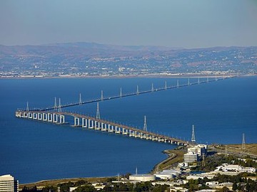
San Mateo-Hayward Bridge
The San Mateo–Hayward Bridge is a bridge crossing the American state of California's San Francisco Bay, linking the San Francisco Peninsula with the East Bay. The bridge's western end... Wikipedia
- Carries: 6 lanes of
- Crosses: San Francisco Bay
- Locale: Foster City and Hayward, California, United States
- Other name(s): San Mateo Bridge
- Owner: State of California
- Maintained by: Caltrans and BATA
- ID number: 35 0054
- Website: www.bayareafastrak.org Official site
- Design: Orthotropic deck (western highrise span), trestle (eastern causeway spans)
- Total length: 36,960 ft (11,265.41 m), 7 mi (11.27 km)
- Width: 41 m (134.51 ft) roadway approach
- Longest span: 757.2 ft (230.79 m)
- Number of spans: 37 (highrise), 871 (causeway)
- Clearance below: 134.5 ft (41 m)
- Designer: Caltrans, Bay Toll Crossings Division
- Constructed by: superstructure: Murphy Pacific Bridge Builders, Emeryville, substructure: Pomeroy-Gerwick-Steers, San Francisco
- Fabrication by: Murphy Pacific Corporation, Emeryville
- Construction cost: $70,000,000 (equivalent to $ in Error: undefined index "US-GDP" when using.)
- Daily traffic: 93,000
- Toll: Westbound only, FasTrak or pay-by-plate, cash not accepted, Effective 2026-01-01 – 2026-12-31 (2026-01-01 – 2026-12-31), $8.50, $4.25 (carpool rush hours, FasTrak only)
- Data source: DuckDuckGo